
New Brunswick · Tidal coast
Bay of Fundy Coastal Road Trip
On the Fundy coast, the clock on the itinerary is partly a tide table. Build the route around a few coastal bases, give the same shoreline time to change, and keep enough flexibility for weather, road conditions and park access.
- Region
- Moncton–Fundy coast–Saint John–St. Andrews, New Brunswick
- Best for
- First-time Atlantic Canada road-trippers and families
- Season
- Late spring through fall for the full visitor route; verify seasonal operations
- Time
- Seven to ten days for Tourism New Brunswick’s full Fundy Coast Road Trip
By Horizon Outdoor Editorial TeamPublished 2026-09-10
Quick facts
- Official route pace
- Seven to ten days for the full coast itinerary
- Eastern anchors
- Hopewell Rocks and Fundy National Park
- Western anchors
- Saint John, New River Beach and St. Andrews area
- Daily checks
- Tide window, park access, weather and NB 511
Use the official coastal route as a framework, not a checklist
Tourism New Brunswick presents a seven-to-ten-day Fundy Coast Road Trip joining the Moncton side of the bay with Fundy-Albert, Fundy National Park, Saint John and the western coast toward St. Andrews. It can be driven in either direction. Start from the province or transport connection that produces the simplest arrival and final exit.
A first trip is calmer with three or four bases: one near the eastern tides, one around Fundy National Park or Alma, one near Saint John, and an optional western-coast base. Do not change rooms simply to claim another town; move when the next base meaningfully improves access to the following day.
- Base 1: eastern Fundy and Hopewell area
- Base 2: Fundy National Park and Alma
- Base 3: Saint John
- Optional Base 4: western coast and St. Andrews
Put tide-dependent activities on the calendar first
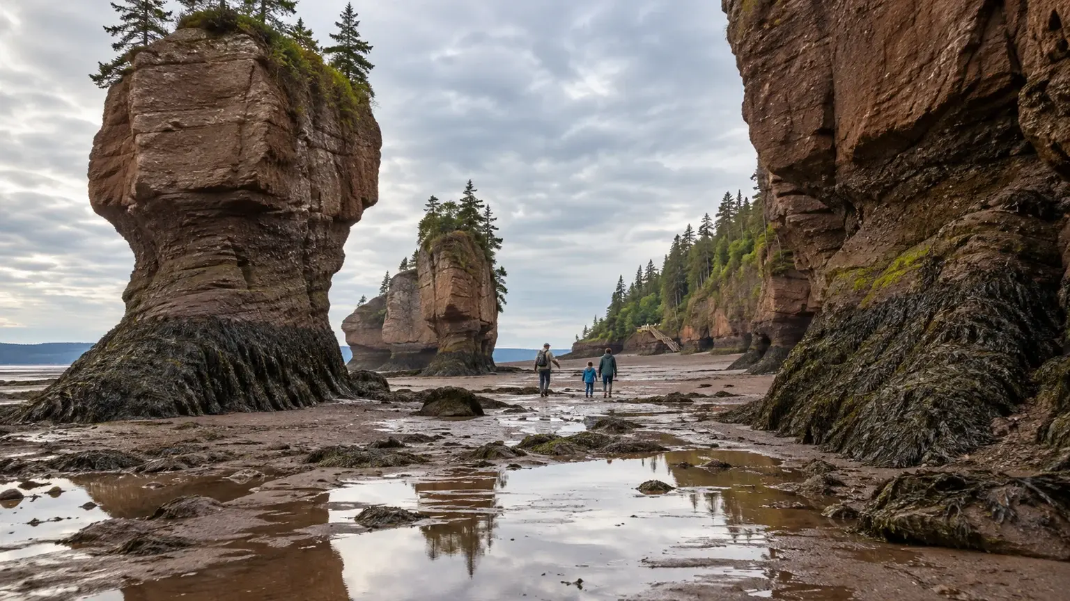
At Hopewell Rocks, ocean-floor access depends on the tide and park staff. Use the park’s own tide table and current hours, and remember that the displayed time zone matters. The ticket policy and access arrangements can change, so read the current visit information rather than copying an old itinerary.
Seeing the coast at both lower and higher water can reveal the scale of the bay, but it requires waiting or returning. Build nearby meals, interpretation or a second day into the plan instead of driving far away between tide windows. Never enter a closed ocean-floor area or assume a predicted low tide overrides staff direction.
- Use the exact attraction’s current tide and access information
- Plan the waiting interval before arrival
- Follow staff closure decisions even when a table suggests low water
Give Fundy National Park a land-based day
Fundy National Park adds Acadian forest, waterfalls, lakes, trails and its own shoreline. Use the current park map and trail guide to choose one compatible cluster rather than treating the park as a scenic road between Alma and the next hotel. Access notices can affect specific areas even when the park remains open.
Keep one shorter trail or visitor-centre option for wet or low-visibility weather. Check hours, reservations, superintendent notices and the activity page before departure. Tides are part of the park landscape, but inland experiences give the route a useful alternative when the exposed coast is not comfortable.
- Choose one park activity cluster
- Read current access and trail notices
- Keep an inland weather alternative
Protect the transfer through Saint John and the western coast
The route west includes working communities, urban traffic, coastal roads and optional islands or ferries. Decide which experience matters before adding a ferry or island timetable. A city night in Saint John can separate two coastal sections and prevent a long day from absorbing every unplanned stop.
Check New Brunswick 511 for road conditions, construction, flooding and applicable ferry status. Stop only where parking is legal and follow the current access process for any road or causeway affected by tides. A coastal map image is not enough to prove that a route is open now.
- Choose island or ferry additions before booking the day
- Use Saint John as a practical route break when helpful
- Check NB 511 and the destination operator
Keep one weather-and-tide buffer in the route
Rain, fog, wind, high water or an access closure can shift the best coastal hour. Leave one half-day or full day without a distant transfer so a tide-dependent visit can move. If the buffer is not needed, use it for a town, beach, park trail or earlier check-in close to the current base.
Keep dry and wind layers, footwear for mud or wet surfaces, water and food reachable. The Bay of Fundy rewards attention to change. A good itinerary does not fight the tide table; it uses that rhythm to make fewer, better coastal decisions.
- Hold one movable coastal block
- Keep wet-weather layers in the day bag
- Remove a bonus stop before compressing the tide window
Common planning mistakes
- Treating the official seven-to-ten-day route as a requirement to stop everywhere
- Using a general tide app instead of the exact attraction information
- Assuming low tide guarantees ocean-floor access
- Driving through Fundy National Park without planning a park day
- Adding ferries or islands before checking the complete timetable
Printable companion
Download the family road trip checklist
A printable family list for car comfort, weather changes, food stops, simple outdoor days and backup plans.
Download the free PDFQuestions travellers ask
How long does the full New Brunswick Fundy coast need?
Tourism New Brunswick presents its full Fundy Coast Road Trip as seven to ten days. A shorter trip should choose one section and fewer bases rather than compress every anchor.
Should we see Hopewell Rocks at high tide or low tide?
Either is meaningful, and the park suggests that many visitors compare both. Use its current tide table, hours and staff-controlled ocean-floor access.
Is Fundy National Park only a coastal viewpoint?
No. It includes forest, waterfalls, lakes, trails and shoreline. Give it a separate activity plan based on the current park map and notices.
What should we check each morning?
Review the relevant tide window, destination access, Environment Canada forecast, NB 511, legal parking, fuel and the next accommodation or ferry commitment.
Sources and currency
Conditions change. Confirm dynamic details again before departure; each source shows its own last-checked date.
- Tourism New Brunswick: Fundy Coast Road Trip (2026-09-10)
- NB Parks: Hopewell Rocks tide tables and ocean-floor access (2026-09-10)
- Parks Canada: Fundy National Park visitor planning (2026-09-10)
- Parks Canada: Fundy National Park maps and trail guides (2026-09-10)
- New Brunswick 511: New Brunswick road and ferry information (2026-09-10)
- Environment and Climate Change Canada: Canadian weather forecasts and alerts (2026-09-10)
Continue planning
Related field guides
Canada · First national park trip
Canada National Parks First-Time Guide
A first national park visit works best when the logistics are visible before the scenery takes over: entry, reservations, roads, weather, wildlife and a day plan that can shrink.
Open the guide
Nova Scotia · Cape Breton
Cabot Trail Road Trip Guide
The Cabot Trail is not a loop to finish. It is a coastal-and-highland drive where the best moments often come from slowing down.
Open the guide
Printable planning guide
Canada Road Trip Packing Checklist
Start with the essentials that protect the trip, then remove anything your route, season and travelling party do not need.
Open the guide